Man Overboard
March 7th, 2011 Clive and I went sailing in the San Francisco Bay with the sole purpose of practicing man-overboard procedures. We set out from Alameda on a 33’ sloop on the backside of a windy and rainy weather front that passed through the night before. There was no rain with a partly cloudy sky and wind in the high-teens, gusting to the low 20s, and these were the closest conditions we could find that would resemble the ocean. A few weeks prior to this practice I sent out an e-mail to several sailing friends that went something like this: I need real-time mono-hull MOB practice preferably in SF rough water under sail. If anyone knows anyone willing to go out and do some serious practice please make the connection for me. I need to complete this prior to an April delivery. I did not receive very many favorable responses so Clive and I took it upon ourselves and practiced with only the two of us on a rented boat; which actually made for more effort and focus.
Granted, there are many rules on boats and one of them heard quite often is, don’t fall off. Since it does happen, it is best to have some idea how to retrieve the person or object from the water. The standard method of retrieval has been reduced to a short list of items that should be adhered to and specifically, are: someone yells man overboard, someone throws a flotation device, someone acts as the spotter by pointing in the direction of the man overboard and does nothing else, and the remaining crew turns the boat around. Within these simple steps is an almost infinite and extensive list of variations and peripheral items which are too many to list here.
Hats fall off boats quite often, and are usually given up and left behind because small dark objects can sometimes be extremely difficult to find. People, somewhat much easier to spot, are a different story. I admit we put forth all our effort to find people; I know, very re-assuring. Unfortunately, in the old days and I mean prior to the invention of the Bermuda Sloop in the 1600s, if you fell off the vessel you were most likely left behind because it was either impossible to turn the boat around or no one knew you went overboard.

The Bermuda Sloop, later also referred to as the Marconi rig, has in its purest form a single mast and is the basis for nearly all modern sailboats. The Bermudas lie in a line near parallel to the prevailing winds from the West and the ability to sail upwind was vital to transit around the archipelago. The fore-and-aft rig was particularly useful in maneuvering upwind. On the contrary, most other types of sailing ships could not go very far upwind, if at all, and used their baggy sails like a spinnaker to sail away from the wind.
Old ships had wooden masts and hulls powered by square-rigged canvas sails that were poor at upwind sailing. Square sails are mounted on a yard, which is a big horizontal pole mounted on the mast. The mast, in turn, is supported by "stays"; ropes that run from the top of the mast to the ship's hull in all directions and are essential to keep the mast upright given the tremendous forces it must bear. The yard upon which the sail is mounted can only rotate so far before it collides with the stays in front of the mast. Old square-rigged ships cannot efficiently sail upwind simply because the yards and sails cannot rotate enough without hitting the stays.
The Bermuda Sloop sails upwind by using a triangular sail that is not mounted on a yard. The triangular shape of the sail allows it to fit within the stays and with triangular shaped sails, goes upwind better than square-riggers. Sailors of the olden wood ships era did not understand how upwind sailing worked; they knew how to sail upwind but did not know why it worked. A modern well-designed boat using a sail as an airfoil and a keel as an opposing hydrofoil can actually sail faster than the wind. However, give credit where credit is due, the concept of the airfoil wouldn’t come until the 20th century.
As recently as the last few decades, it was quietly known that if you fell off a high-performance sailboat offshore you would most likely never be found. The high speed of the boat greatly increased the distance from the person in the water before the boat could be turned around; and it then was just too hard to spot the person in rough water. Current advances in technology have made useful contributions to the success of retrieving persons in the water and in a sense have created a wide safety net.
Immediately after a person has gone overboard the helmsman must make the decision to turn the boat around. Sometimes, confusion erupts while choosing which way to turn and how many turns to make. The textbook descriptions really only depict two techniques: the Figure Eight and the Quick Stop. There are many variations on just these two techniques but overall the point of sail, wind and wave conditions will ultimately dictate which one to use.
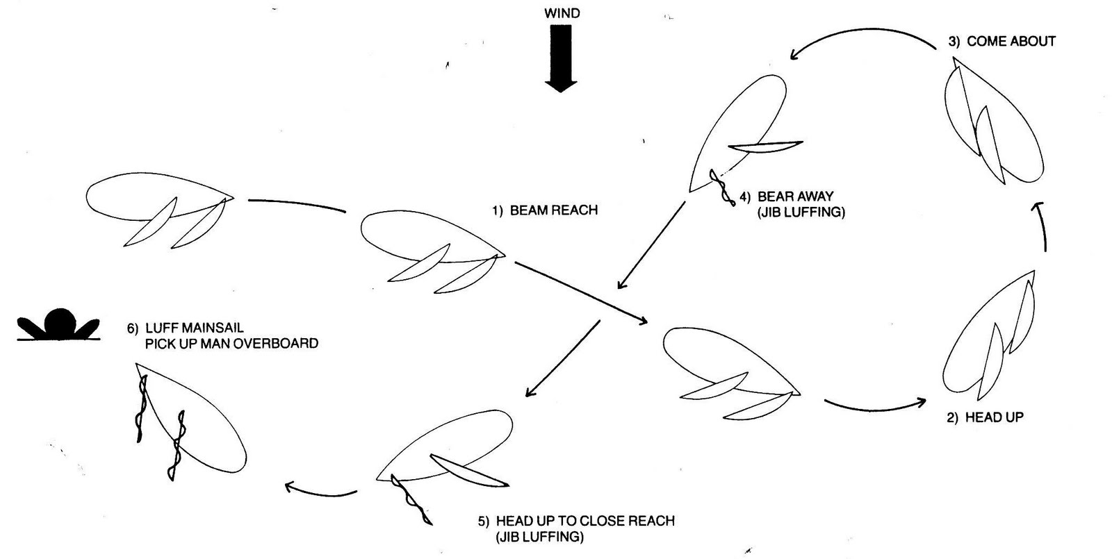
Figure Eight

For our practice sail on the bay I intended to throw oranges overboard and use them as targets. I knew they were biodegradable and would not harm the environment. Well, after losing several oranges we had to use a large white fender with a loop in the line that we tied to it. It just so happens that when there are 2’ waves and whitecaps the oranges disappear. Good to know.
 |
| Our GPS track is highlighted in orange southwest of Alameda, CA |


Our total time on the water was about four hours and of that time, we spent roughly 2 hours doing the actual procedures. I think the most successful and effective technique is the Figure Eight. We were able to judge the distances with more accuracy and were able to get to the object on the first pass compared to the quick stop method. During the quick stop we found that we turned too quickly and actually could not make the radius of the turn small enough to get to the object. We eventually increased the radius and had to sail away from the object to get back to it.
When planning a long-distance passage I take into consideration many aspects with respect to falling overboard. Whether I am injured or not in the act of going overboard, all the safety gear on board or with me will not help if the crew and I don’t know how to use it. Water temperature is also an important factor in survivability but preparing for it can be difficult. It is nearly impossible to work during watches while wearing immersion suits because of the impaired lack of mobility. So, underneath our foul weather pants and jacket we generally wear what keeps us warm.
 |
| Mustang Survival Series PFD |
For MOB planning purposes I allow for day and night situations and wear a “Mustang Survival” inflatable PFD (personal-flotation-device). This device has an integrated harness and an automatic hydrostatic inflator which works on hydrostatic pressure; namely, a c02 cylinder discharges and inflates the vest’s air-bladder when submerged in 4 inches of water and is not sensitive to humidity, rain or splash. This unit can also be manually inflated by pulling a ripcord to activate the c02 cartridge; or by using the attached oral-inflation tube.

The vest zip-folds closed and will remain compact while not in use but once deployed it will automatically expand and reveal the yellow air bladder. Also, additional items that will help identify your position in the water can be attached easily because of the design of the vest. At the very least, a water-activated strobe light should be attached. I prefer the water-activated ACR Firefly Waterbug; waterproof to a depth of 33 feet and can be seen up to three miles away. In addition, below the strobe is a manually activated ACR C-Light that imitates a strobe with a fixed curved lens but with no flashes; and can be seen up to two miles away.
For the very real possibility that the distance from the boat keeps increasing there is a Rescue Laser Flare attached to the vest. This compact item looks like a standard laser pointer but emits a fan of light rather than a narrow beam and is visible up to twenty miles away at night; visible up to three miles in daylight.
In addition to these items I carry a waterproof VHF, GPS and whistle in hopes of communicating with the boat if I cannot be seen, but they are still in VHF range.
Once these items have been exhausted in the sense that the boat cannot find me I have planned for a Search & Recovery rescue. I will assume that the boat has broadcast a Mayday for a lost crew-member either over the SSB radio (single-sideband modulation is a refinement of amplitude modulation and more efficiently uses electrical power and bandwidth), or with an EPIRB (Emergency Position Indicating Radio Beacon). VHF signals and cell phones have very limited ranges and do not work well offshore. A very quick way to communicate with rescue authorities is with a satellite phone and they have become more common on sailboats. Ultimately, the quickest and most accurate way to convey that an emergency does exist is by using either an EPRIB or a PLB (personal locating beacon). These critical pieces of last-resort lifesaving gear are connected to a global government-run satellite network. Once activated, a chain of responses occurs.

One of the greatest pieces of equipment available, to help an overboard individual who is assumed lost, is the PLB (personal locator beacon). I registered an ACR AquaLink View with NOAA as required and attached it to my PFD. The National Oceanic and Atmospheric Administration (NOAA) is a scientific agency within the United States Department of Commerce focused on the conditions of the oceans and the atmosphere.

EPIRBs and PLBs transmit signals with an embedded code that is picked up by a network of 24 satellites linked to Cospas-Sarsat; an international satellite-based search and rescue (SAR) distress alert-detection and information-distribution system consisting of both a ground segment and a space segment; established by Canada, France, the United States, and the former Soviet Union in 1979. COSPAS is an acronym for the Russian words "Cosmicheskaya Sistema Poiska Avariynyh Sudov", which translates to "Space System for the Search of Vessels in Distress" and SARSAT is an acronym for Search And Rescue Satellite-Aided Tracking.
Once the Aqualink is manually activated, it broadcasts a unique registered distress signal that communicates to rescuers, who you are and where you are, to within approximately 300 feet. The unit emits a powerful signal over the internationally recognized 406MHz distress frequency and relays information to orbiting satellites.
The basic Cospas-Sarsat concept starts with a signal transmitted from a radio beacon associated with ELTs (emergency locator transmitter) for aviation use, EPIRBs for maritime use, and PLBs for personal use). Instruments on board satellites in geostationary and low-altitude Earth-orbits, detect the signals transmitted by distress radio beacons and relay the information to ground receiving stations, which are referred to as Local Users Terminals (LUTs). Mission Control Centers receive alerts produced by LUTs and while tracking the signal, MCC’s attempt to identify the transmitting vessel by using the database of registered EPRIBS. This information is then forwarded to a regional Rescue Coordination Center (RCC).

Satellites in high geostationary Earth orbit (GEO) form the GEOSAR System providing almost instantaneous alerting, continuous coverage of the same area of the Earth’s surface, but no position location. The GEOSAR system consists of 406 MHz repeaters carried on board various geostationary satellites that orbit at an altitude of approximately 23,000 miles and remain fixed relative to the Earth. These satellites are not effective for viewing the latitudes at the poles due to the increased angle between the satellite and the Earth’s surface.

GEOSAR satellite footprint

LEOSAR satellite footprint
Satellites in low-altitude Earth orbit (LEO) form the LEOSAR System, move from pole to pole and have global coverage but not instantaneous alerting. The two systems are complimentary wherein the LEOSAR system provides coverage of the Polar Regions (which are beyond the coverage of geostationary satellites). The LEOSAR system can calculate the location of distress events and is less susceptible to obstructions because the satellite is continuously moving with respect to the beacon.

LEOSAR coverage is not continuous because polar orbiting satellites can only view a portion of the Earth at any given time. Consequently, the System cannot produce distress alerts until the satellite is in a position where it can "see" the distress beacon. However, since the satellite processor includes a memory module, the satellite is able to store distress beacon information and rebroadcast it when the satellite comes within view of an LUT and the AquaLink View has the same memory feature.

A single satellite circling the Earth around the poles eventually views the entire Earth surface; the path of the satellite remains fixed while the Earth rotates underneath it. It takes only one half rotation of the Earth (12 hours) for any location to pass under the satellite. With a second satellite, having a path at right angles to the first, only one quarter of a rotation is required (6 hours). The Cospas-Sarsat System uses four satellites and provides a typical waiting time of less than one hour at mid-latitudes.
If all goes well to this point and rescue is fairly imminent, the AquaLink emits a separate 121.5 MHz homing signal to help the rescuers. In addition, I attached an environmentally safe dye marker to my Personal Floatation Device. This dye marker is used as a daylight signal to be seen from above, by turning up to 50 sq ft of water bright green. A simple visual signaling device also attached to the PFD is an orally inflated bright orange sausage that is held vertically, for example, to alert a dive-vessel while one is floating on the surface in full scuba gear and waiting for a pick-up. The last item and in no way less important is a 3-pack of Orion Pocket Rocket Signal Flares. These durable and easy to use waterproof flares can be used day and night as a personal distress signal.

In many ways my approach to the planning process is similar to President Eisenhower’s. He knew what he wanted. He could not predict what would happen. So, he planned like mad. Not because the plans would work, but because he would be so disciplined that when something unexpected happened he would be prepared.
No comments:
Post a Comment