 |
| Monday November 28, 2005 |
 |
Sunday October 30, 2005 Bonifacio, Corsica, France 41°23’N 09°08’.8E
 |
| Vessel track October & November 2005 |
|
We departed Fiumicino, Italy on October 29, 2005 in a custom cutter-rigged 58’ Bruce Roberts designed motor-sailer named Amor Fati destined for its homeport of San Diego, CA. Our transit across the Mediterranean from east to west allowed for stops in Bonifacio, Corsica; Menorca and Mallorca in the Islas Baleares island group of Spain; Alicante and Aguadulce, Spain, and Gibraltar. There was rough weather and placid conditions to deal with as to be expected with October and November passages in the Med. We dealt with many issues confronting all sailors; provisioning, weather routing, engine and equipment problems, a line wrapped on the prop shaft, cold and warm weather and the coup de grace, a schedule. Our goal was to get the vessel to Barbados by December 18 to celebrate Christmas with wives and friends, and then on through the Panama Canal to California.
John Settles & Alain Gronner, respectfully, aboard S/V Amor Fati approaching Gibraltar from the east on 11/18/05.
David Berke, aboard S/V Amor Fati approaching The Islas Canarias from the northeast on 11/27/05.
The crew consisted of John the owner, Alan and me. There are many aspects of our voyage across the Mediterranean and into the Atlantic worthy of mention but our experience just after landfall at the new Marina Rubicon in Playa Blanca, Lanzarote, Islas Canarias was definitely extraordinary.
 |
| Satellite image 11/21/05 |
 |
| Satellite image 11/22/05 |
In Gibraltar we rested, worked on the boat, did some sightseeing, provisioned and left after the current weather system affecting the area moved east. On Monday November 21, John talked to his wife Nancy in San Diego for a weather update; she was our weather router. She said to leave the next morning, as there appeared to be a decent weather window for the planned 5-day passage. She also commented that there was an interesting weather system forming southwest of The Canaries. Unfortunately, we needed most of the next day to finish our to-do list before we could depart. Based on Nancy’s information and weather forecasting graphics that we attained online at the local Internet café we were under the impression that our passage to The Canaries was going to be peaceful with 10-20 knot winds aft and following seas. Fat, dumb and happy we departed Gibraltar on the morning of November 23rd.
 |
| 11/25/05 Drifting 47 miles west of Casablanca, Morocco |
 |
| Going in circles while drifting. |
Unfortunately, we had a twelve-and-a-half-hour delay on the 25th into the 26th due to a failed radiator hose at 10:30 p.m. that caused the engine to overheat and subsequently spray radiator fluid all over the engine room. We had been motoring because the wind ceased and now that we had no motor we were slowly drifting east from about 47 miles west of Casablanca, Morocco. We were rolling all over the place and there was no way to stop it. The sun came up in a quiet, peaceful, beautiful partly cloudy blue sky while in the cockpit John and I reflected. After checking the GPS John said, “At this rate we’ll be on the beach in 3 days”. I pointed east and asked, “Morocco?” He responded with a simple nod yes. Then a little later after checking the GPS again he says, “At this speed we’ll be in the Canaries on December 20th”. That was, uhm, 25 days away. This was supposed to be a 5-day passage. At least there was humor.
Between the efforts of John and Alan the engine came to life again at 11:00 a.m. and we were off. We had to make a decision as to continuing on to the Canaries. A call was made on the satellite phone to Nancy to get a weather update. She informed us that the system had slowed slightly, was forming into something and that we had better kick it in gear and get going if we were to beat it there. The next two days we motored and sailed our way towards Lanzarote.
We assessed the prediction of a storm possibly nearing the Islas Canarias around our proposed arrival and we were hoping to beat it there. Our planned route speculated us making port about a day in advance of the storm providing there were no delays along the way. Scheduling a passage this tight between weather systems can be unnerving at times and if there actually is a delay in transit or a change in the forecast then bail-out options have to be considered. The only option we had was to head east for Morocco to find a safe haven and wait it out.
Well offshore the day before while approaching Lanzarote, we saw a lone dolphin at the bow, rain showers, a rainbow and whale spouts backlit by the late afternoon sun. This was nature at its finest while we ghosted along the 10 to 15 foot following swells of about 300’ feet apart. The dawn arrival on the 28th into the marina greeted us with flat seas and calm winds. We made it to our planned destination in advance of the weather system. While still sitting at the check-in dock John called Nancy and were we surprised! She said the system was named Delta since it was now considered a tropical storm.
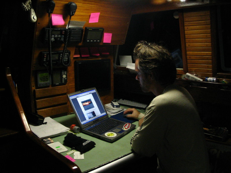
After checking in and talking with some locals we heard some interesting responses to our inquiries about the storm. Several people at the marina office were unaware; thought the sun was going to shine all day with light winds and pleasant temperatures. At least one person at the dive shop knew something. She said the storm was on its way, that it was big, the schools were already closed on La Palma and they were expecting widespread damage in The Canaries. During check-in we attained Internet Wi-Fi pass-codes and after getting to our assigned slip we all checked our e-mail and then I researched the weather forecasts.
 |
| The Azores, Portugal upper left. |
Through news reports I learned that on Wednesday November 23rd the twenty-fifth named storm of the season had formed in the Atlantic. Tropical storm Delta with sustained winds of 70 mph and expected to intensify was at that time centered 1,160 miles southwest of the Azores, which are approximately 850 miles west of mainland Portugal. The storm was large, with tropical storm-force winds stretching 230 miles from its center. The National Hurricane Center stated, “…poses a threat only to shipping”. And, according to hurricane specialist Stacy Stewart “…it’s way out in the middle of nowhere.”
 |
| Tropical Storm Delta as seen west of Africa in this satellite image taken 11/28/05 at 7 p.m. EST. |
On November 28 at 10p.m. EST, Delta had top sustained winds of near 65 mph, up from 40 mph earlier in the day. The storm was centered about 475 miles west of La Palma in the Canary Islands and moving east-northeast near 26 mph. Of note, La Palma is the most northwestern island of the chain and is the location of the world’s largest volcanic crater named La Caldera de Taburiente. Delta was, “…expected to lose the characteristics of a tropical storm before reaching the Canary Islands off the northwestern coast of Africa on Monday but still could have strong winds,” the hurricane center said.
 |
Amor Fati was located in I-10 E at the lower right.
|
The day proceeded peacefully with the winds increasing very slowly and then remaining in the teens until late afternoon. There were occasional sprinkles and small patches of blue in mostly cloudy skies. The wind waves on the other side of the 25’ seawall that protected the marina had increased to a frenzied sloppy four to five feet out of the west-southwest. The sky was a bit ominous looking outside and we decided to stay in and avoid getting wet while walking through town. It wasn’t until after the sun went down and the early evening hours that we noticed the winds had increased substantially and were now sustained in the high twenties from west-southwest. The noise caught our attention. We watched the steady increase over the next four hours to sustained winds in the 30s, the 40s, the 50s and gusts to the low sixties.
 |
| Amor Fati 11/28/05 |
 |
| Amor Fati 11/28/05 |
 |
| Amor Fati 11/29/05 |
During the peak of the storm the marina was alive with people tending boats that were tied to the docks. When the winds were sustained in the 40s damage started occurring. Sails started shredding on vessels and vessels were hitting the docks. The noise of the winds blowing through masts and rigging was incredible and reminiscent of a freight train. Several times through the night we put on foulies and went outside to add and tighten dock lines, move fenders, secure sails and canvas and have a look around our general area. There was intermittent light rain, yet while outside we were still pelted with stinging particles in the air. We determined it was a combination of granules of dirt, sand and salt partly from the waves coming over the seawall. The force of the wind gusts was more than enough at times to nearly knock you off your feet and made navigating the docks fairly risky. Another concern being outside was the possibility of getting hit by flying debris.


 |
| 1:30 am Rum cheers to the passing of the eye of the storm. |
 |
Amor Fati 11/29/05
|
 |
| Not, Amor Fati | | | | |
|
 |
| Dead fish on the quay. | | | | | | |
|
|
 |
The seawall took a beating.
| |
|
|
The Genoa on a neighbor vessel off our bow began to unravel during the high 40s and several people managed to get it secured. That noise alone drew a lot of attention. During the early part of the storm the winds from the west-southwest favored blowing our boat and vessel away from the dock and luckily we were faced west with the bow to the wind. This became a deciding factor as to damage to boats. All we had to be concerned with was keeping the boat tied to the dock. The minimal amount of fenders was adequate for the conditions. When the winds were in the 50s and shifting through west into west-northwest one of our bowlines broke as we were being pushed into the dock on our port side. Our fenders were being smashed and one of them popped. Our vessel was heeling and banging against the dock and our greatest concerns were broken dock lines, crushed fenders and damaging the boat and sails. At this time we recorded a peak of 61 knots at our mast.
Luckily, the marina was not full and we had no direct neighbor. The vessels with people onboard were tended to and some of the vessels with no one present were vulnerable. All the vessels in the water were moving back and forth excessively as if swinging on the hook when large wakes go by. True to the nature of all boaters, good Samaritans were securing various vessels in their areas. The motor-sailer several slips down and across from us was moving excessively in its slip. It was vacant and obviously in distress. From out our window we could see that its reverse transom was hitting the dock. During the sustained winds in the 50s John tended to the vessel trying to get a fender in place. He managed to get a fender off the side of the boat that was not against a dock and during the cycling of heaving to and from the dock he managed to get the fender between the damaged area and the dock. The winds and forces were far too great to be able to free dock lines and re-tie them. That one fender alone stopped any more damage from occurring.
Sitting inside our vessel listening to the roaring wind and feeling the boat rocking and rolling and the jolts from the dock lines made us realize how incredibly lucky we were to have made it safely to port before this storm. The next day we learned that during the storm a vessel in distress northeast of here off the coast of Puerto Calero fired flares and the crew was subsequently rescued by helicopter. A small open wooden boat was sunk in the harbor by collisions with the tourist submarine. The submarine also suffered extensive fiberglass damage to its starboard bow from colliding with the dock. This occurred in the basin right at the marina office where they recorded peak winds of 75 knots.
Marina Rubicon, Playa Blanca, Lanzarote, Islas Canarias 28° 51’ 5” N 013° 49’ 0” W

Several other incidents occurred that resulted in damage to vessels. The largest vessel tied to the dock in this marina was a beautiful dark blue ketch displacing 140 tons pointing south. During the peak winds of 75 knots at their mast, they were pushed broadside against the dock, which caused the dock to start breaking apart. When the dock started going vertical the crew removed 2 of the passengers to a local hotel and they came back and sat in their car on the quay for a portion of the storm watching the events unfold. This vessel is a steel hull and that is probably the only reason it survived the extensive damage to its port side. The gunwale is approximately 5 feet above the waterline and that was damaged from hitting the dock. Also, the small sailboat perpendicular to the vertical dock sustained bow damage because now the dock was rising up and colliding with it. There were many boats with damage to their bows as they hit the docks while flexing their lines. Generally, boats that were on the downwind side of the dock did not sustain much fore and aft damage and boats that were on the upwind side of the docks received bow and stern damage. It very much mattered which side of the dock you were tied to and the direction the prevailing storm winds were coming from.
Many vessels suffered chafe damage from lines rubbing on wood and fiberglass; fenders, lines and docks damaged the hulls; and it seems the most chafing damage came from spring lines. Several headsails were in tatters. The large stainless roller and bowsprit on a ketch managed to bend and dent the steel railing of the dock walkway from colliding with it. There was just no way of stopping these boats from cycling back and forth in the brunt of the storm. In the early morning hours there was a display of dock lines spanning the waterways going all directions and were the result of a long night for all.
Surprisingly, of several vessels in the small boatyard not one had fallen off the stands while on the hard. Of special note is what happened to the high-tech experimental tri-maran that was on the quay in temporary storage. This vessel was constructed to attempt speed records with its non-conforming design and is sponsored by a major aircraft manufacturer. It was blown across the 2-lane pavement while dragging its un-stepped carbon-fiber mast and a 40’ steel container. It ended up teetering off the quay with the starboard outrigger floating in the water. The mast snapped in half, the steel container was dented, a 4x4 concrete power and light box snapped and was hanging off the quay and the vessel itself sustained various damage. The good news is that after it was lifted back onto the quay it appeared to be salvable.
Hydroptere Marina Rubicon, Playa Blanca, Lanzarote, Islas Canarias 28° 51’ 5” N 013° 49’ 0” W
Amor Fati, 58’ Bruce Roberts
John & Nancy Settles, owners
San Diego, CA


