Wednesday 12.07.05 535pm
21° 07.804 N 026° 23.724 W
1,960 nm to Barbados
A boat was just spotted off the aft starboard quarter. Still trying to figure out what it is. I’m going to cook the rest of the Dorado, some potatoes and fresh bread for dinner. It’s pretty bumpy out here. We’ve been rolling all day and I hope it stops. It is so hard to sleep in these conditions.
The ship was a large tanker. Soon after we spotted it and it got within 5 miles of us it made a hard right turn. At first we were looking at its starboard side and then we were looking at the entire port side. It was parallel to us about 2-1/2 miles away and stayed in that relative position until it disappeared on the horizon.
Sometime during sunset Alan started working on the windlass switch in the forward hatch. It had been inoperative since Fornells, Menorca. During this time I was making dinner, reading, typing, etc. Anyway, I’m in the galley and its pretty rough and John is on the step and we’re talking. Then he leans out the window and yells to Alan, “One hand for the boat…!” Without missing a beat Alan responds with, “John I need you to come forward and look at what I’ve done”. I said, “One hand for the boat.” Earlier when I was in the cockpit, waiting for the bread to rise John asked me to keep an eye on Alan since he was going forward to work on the hatch and it was rough and getting dark.
Thursday 12.08.05 1234pm
19° 56.827 N 27° 31.369 W (we’ve crossed 20° on our way to 13°!)
1,887 nm northeast of Barbados
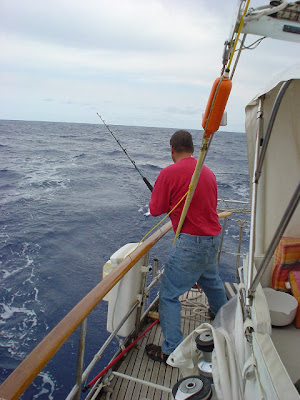
After pancakes this morning John and I were sitting in the cockpit reminiscing about cars and teenage years. While looking over the starboard side I saw 2 fish jump out of the water within half a minute of each other. I jumped up and put the pole out. Went forward up to the chair to read and soak up some cloudy sun and in less than an hour I hear, Fish! John reeled in a yellowtail tuna! Alan was busy working on the pedestal; I cleaned it and John scooped the water.
That’s dirt from the storm back in Lanzarote. It appears to be some of the rich volcanic soil that is similar in color to Hawaii in places.
Friday 12.09.05
19° 26.240 N 029° 14.537 W
1,787 nm to Barbados
932am
I found John and told him food in 2 minutes. I was making corned beef hash and eggs. When he looked at it he said, what’s that? followed by, oh. When John and I shopped in Gibraltar we found one can in a little shop on the side street and not in Safeway. We planned on having it with eggs for breakfast.
12.09.05 953am 135nm northwest of The Cape Verde islands off the west coast of Africa.
This image is a copy of the image we see on the LCD screen at the nav station. The software is Nobeltec. This perfect image, not like all my previous digital photo images, is the result of lots of time on my hands and patience. It’s not as easy as it appears to get this image off the computer on the boat. First, I insert the flash drive into the USB port on the computer in the starboard lower cabinet that runs the nav program.
Second, I have to save the image from the screen and I do that by going through the print commands and saving it as an .MDI file on the flash drive. Don’t ask me why this is the process. Third, put the flash drive in my laptop and open it with Microsoft Office Document Imaging. With this program I then save it as a .TIFF file. Fourth, I open the .TIFF file with Microsoft Office Picture Manager. In that program I am able to crop and modify the original image and then save it as a .JPG file. I need the image in the .JPG format in order to insert it in a Word document, which is what these journal pages are.
Anyway, back to the image above. The red line is our track yesterday, last night and then dawn today. Yesterday, the little tail at the top right makes a distinct turn to the left, port. That’s when the winds were up and favorable for us to sail in the direction we wanted to go. The long continuous straight line to the southwest was a direct result of the wind machine blowing steady in one direction. Right before we reached the 20th parallel the winds shifted and we had to tack by changing our heading by about 30° to 45°. On this particular tack that is depicted as a half-moon on the chart the wind was coming over our starboard side and the sails were filled and billowing on the port side. The reason the line is in the shape of a half-moon is the wind continuously changed the direction it was coming from and we followed it. When the wind was well below 10 knots it caused the boat to wallow and only move forward at the rate of 2-3 knots. At 4:45am this morning, in the dark, I furled the 110% Genoa; John raised the mainsail and started the engine. The distinct sharp turn to port is when we pointed the boat to Barbados, 1,787nm (nautical miles) to the southwest and applied power to reach the speed of 6.5-7 knots.
We are at the mercy of the environment and specifically the strength of the wind, the direction the wind comes from, the size of the waves and the direction they come from, also. When the winds come up again and the conditions are favorable we will raise the sails and blend in with the sea.


No comments:
Post a Comment